


Dangerous Thunderstorms and Isolated Tornadoes Possible in Southern Ontario
- Weather Watch

- Sep 13, 2019
- 3 min read
We are watching the risk for severe thunderstorms and isolated tornadoes across Southwestern Ontario with a lower risk continuing into Eastern Ontario.
Discussion:
We are monitoring the conditions across Southwestern Ontario for the development of conditions which could favor severe thunderstorms and tornadoes. A warm front is pushing into Southern Ontario this morning and will continue to push further into the province throughout the afternoon. Following the warm front, cloud cover is expected to linger across most of the region before a cold front slides across the region. Across the Extreme Southwest extending into portions of Southwestern Ontario, the clouds have the potential to clear allowing for sunshine and warming temperatures. If the clouds can clear before the cold front arrives, severe thunderstorms may develop as across the region ahead of the cold front. These cells contain the potential to rotate due to high shear (spin) in the atmosphere. Due to this potential, we have went with a high risk for severe thunderstorms across portions of the region. Following these possible cells, a linear line of thunderstorms will cross the region bringing widespread damaging winds. An embedded tornado is possible with this line of storms, although, the risk is much lower than isolated cells.
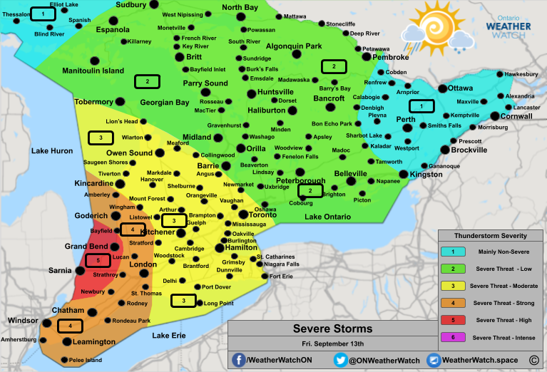
A detailed region-based outlook per severe level can be found below including possible hazards in each category.
Areas in red and marked with a '5' can expect a high risk for severe thunderstorms and possible tornadoes. This region extends from Lake Huron south towards Lake St. Clair including most of Lambton County and the shores of Lake Huron in Huron County (south of Bayfield). In this region, severe thunderstorms seem highly likely due to ongoing clearing across the region. The main threats are wind gusts between 100 and 120km/h, moderate to large hail between 2-3cm and heavy rain. Isolated tornado(es) are possible in this region as well if the conditions described in the discussion are met. This area may need to be extended north further into Huron County towards Goderich and Exeter as well as into Middlesex County further to include Lucan.
Areas in orange and marked with a '4' can expect a strong risk for severe thunderstorms and possible tornadoes. This region extends from Amberley along Highway 86 through to Wingham and continuing south to Lake Erie. This region includes Windsor, Chatham, London, Goderich, and Mitchell. The best risk will be towards the south near Windsor and Chatham where clearing is already occurring. Based on satellite, it appears the clearing may push far enough inland to include those mentioned regions. If this occurs, the severe risk may need to be upgraded or expanded further tornadoes Huron-Perth, Grey-Bruce regions. The main threats are wind gusts between 100-120km/h, heavy rain and moderate to large hail between 1.5 and 2.5cm. Isolated tornado(es) are possible in portions of this region is the conditions described in the discussion are met.
Areas in yellow and marked with a '3' can expect a moderate risk for severe thunderstorms. This region extends from Lion's Head through to Collingwood and Angus to Newmarket, Toronto, and Niagara. This region includes Kitchener, Kincardine, Long Point, Owen Sound, and Hamilton. The main threats are damaging winds between 80 and 100km/h, locally 110km/h. Heavy rain and small to moderate-sized hail are also possible. An isolated tornado may be possible further to the west near the orange and red regions.
Areas in green and marked with a '2' can expect a low risk for severe thunderstorms. This region extends from Manitoulin Island through to Sudbury and Temagami extending south to Pembroke, Denbigh, Kaladar, and Kingston. This region includes Espanola, North Bay, Algonquin Park, Parry Sound, Huntsville, Haliburton, Midland, Orillia, Peterborough, and Belleville. The main risk in these storms will be isolated gusty winds between 70-90km/h. Heavy rain and small hail are also possible in these regions. Most regions will just showers and an isolated thunderstorm. The biggest threat is along Lake Ontario.
Elsewhere in blue, non-severe thunderstorms are possible.
Today could get quite dangerous, we will be watching and update as needed.


Comments