


Snowstorm Targets Northern Ontario; Heavy Snow Expected
- Weather Watch

- Nov 20, 2019
- 2 min read
We are currently watching a developing system over the Northern United States/Southern Manitoba which will begin to track into Northwestern Ontario this afternoon and into Northeastern Ontario throughout the night. Snow, at times heavy, can be expected across a large portion of Northern Ontario with widespread snowfall totals in the 10-15cm range. Snowfall totals as high as 20 and even 25cm are possible.
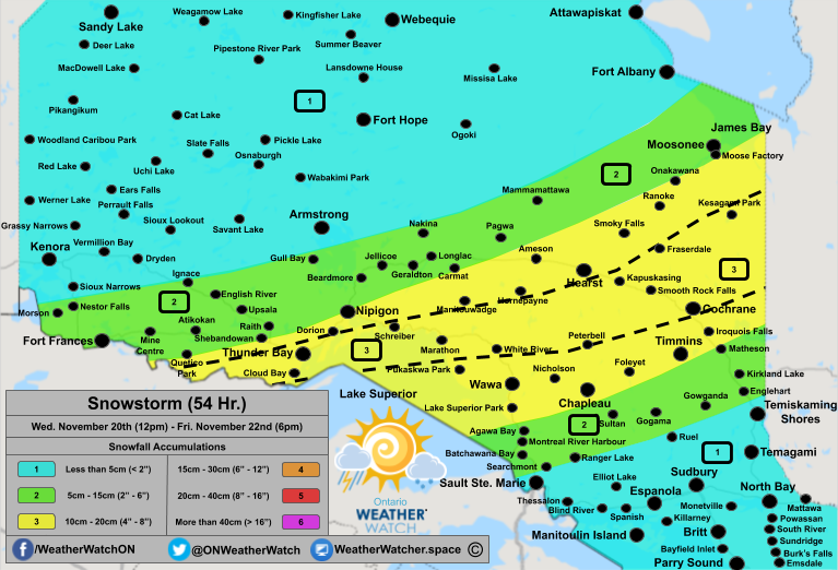
Areas in yellow and marked with a '3' can expect snowfall totals between 10 and 20cm. In Northwestern Ontario from Quetico Park through to Thunder Bay, Cloud Bay, Nipigon, and Dorion, snowfall totals between 12 and 17cm are likely. Between Marathon and Wawa, over Pukaskwa Park, snowfall totals between 13-18cm are likely, although, the precipitation may begin to fall as rain near the shores of Lake Superior. This would lower the snowfall totals in this region to 5-10cm. Extending from Lake Superior towards Quebec including Hearst, Cochrane, Timmins, Chapleau, Fraserdale, Peterbell, Kesagami Park, and Manitouwadge, snowfall totals will range between 10-20cm with the lowest totals to the far north and far south and the highest totals through the centre.
Across the centre of this region where the system will track, in the area between Cochrane and Hearst extending towards White River and Kesagami Park, snowfall totals may reach up to 20cm with local pockets towards 20-30cm of snow. This range of 20-30cm is also possible in Northwestern Ontario from Schreiber through to Quetico Park, although, similar to the area in Northeastern Ontario, this will be isolated and not widespread. This localized 20-30cm range is highlighted in the area of interest.
Areas in the green and marked with a '2' can expect snowfall totals between 5 and 15cm. Towards the north, snowfall totals in Moosonee, Carmat, Shebandowan and Fort Frances will be in the range of 8-12cm. Further north towards Nakina, Gull Bay, Ignace, and Morson, snowfall totals will lower to between 5 and 10cm. Towards the south neard Matheson and Agawa Bay, snowfall totals between 8-12cm can be expected with 5-10cm expected towards Batchawana Bay, Gogama, and Englehart.
Snowfall totals in Armstrong, Ranger Lake, and Ruel may reach into this category of 5-10cm depending on the system's track, although, snowfall totals between 2-5cm is expected at the moment.
Areas in the blue and marked with a '1' can expect snowfall totals under 5cm. This includes area south and north of the green (2) region. Some of these highlighted locations may not see any snow but rather sunshine or rain depending if you are on the north or south side, respectively.
The winds will remain calm for a majority of the system although beginning in the afternoon on Thursday, moderate wind gusts between 40-60km/h may result in blowing snow across the region.
Bus cancellations and school closures are possible on Thursday due to the heavy snow taking place overnight and continuing into the morning. We will update our daily snowday forecast this evening between 8pm and 12am. The forecast as well as closed schools can be found here.


Comentarios